|
|
 |
|
|
|
| |
 |
|
 |
|
|
|
 Many small and cheap ex-USSR air
companies are not included in maybe the most known
international booking system Amadeus,
but in special ex-USSR Sirena
system only. There are not many ticket agents
outside ex-USSR territory with an access to this system and prices seem
to be about 10-20% higher in comparison with local Russian prices. But
it can save a lot of time and organizing if one finds such a ticket
agent in a home country. In the Czech Republic, Asiana is the only companyl.
Fortunately, you can use the Sirena website at least for an exact
planning of the transport. Many small and cheap ex-USSR air
companies are not included in maybe the most known
international booking system Amadeus,
but in special ex-USSR Sirena
system only. There are not many ticket agents
outside ex-USSR territory with an access to this system and prices seem
to be about 10-20% higher in comparison with local Russian prices. But
it can save a lot of time and organizing if one finds such a ticket
agent in a home country. In the Czech Republic, Asiana is the only companyl.
Fortunately, you can use the Sirena website at least for an exact
planning of the transport.
|
|
|
|
|
| |
|
|
|
|
|
|
Visas
You generally need some kind of a
written invitation (called a visa support) to get a Russian visa. I'm
not going to write much about visas , because there
is a lot of information on this topic elsewhere and conditions (means
required documents) can vary a bit in different countries. You can
try e.g. this site (you can even
order an invitation fax through www to be sent to your chosen embassy
and pay by card for this).
Current (2002) situation in the Czech
Republic : Although a tourist visa, issued for
up to 30 days, should require just a simple travel company
invitation to be faxed to an embassy, this kind of invitation is enough
for stay up to approx. 20 days only. For a longer stay, you need to
show some proof of payment for a complete tour or for hotels for the
whole stay. This effectively makes a tourist visa unusable for a
longer independent travelling.
Visa registration
The registration matters are looser
and looser from year to year, expecially in more tourist areas (e.g.
Kamchatka now), but some harassment still remains.
First registration
rule
Everyone with a visa obligation must
have this visa registered till 3 days from an arrival in Russia (the
stamp goes on Migration card when visas are in passports now). If one
does not have this stamp at all, it does not necessarily mean
problems. Usually foreigner is not checked by a police at all
during a several months long journey. The police focuses
on locals, especially Caucasian looking young men.
Sometimes even the visa registration is not checked when leaving
Russia. I was always checked in Brest in Belarusia when leaving Russia
by train (2002,2003). When I was leaving Russian by plane in 2003 in
St. Petersburg, it seemed to me, that they did not look at the back
of the migration card at all...If one does not have the
registration at all then the border policemen can make threats
like getting off the train, require bribe etc. But small
bribe (or nothing at all sometimes) is sufficient, so it can be in fact
cheaper not to bother with the visa registration at all. But it can be
theoretically a more problematic variant as well.
Second registration rule
One should maybe
??? register in every area - means a regional/republic capital
(but I don't know the exact rule and probably no one knows...), where
one intends to stay I guess more than 3? days (at least used to be
the rule in e.g. Kazakstan).
Second and other
registrations can basically be done using same options as the first
registration (see options below). This registration is not
always required when one is checked by local police (I assume one has
at least the first registration mentioned above). But this
not very exact rule provides a constant reason for policemen
to try to make you troubles, require bribes etc...because no one really
knows much about it. Not many people make this registration
anyway, it would be both very annoying and expensive to register e.g.
five times in different parts of Russia.
If one intends to stay in more remote
regions (border regions or distant regions like Yakutia,
Norilsk, Chukotka, Kamchatka ...) local registration can
be usefull. It is usually done in the regional capital of
that area or the capital of a federal republic. Such
regions are quite distant from Moscow and Moscow registration does
not have to be enough for local police. If one reaches final
destination till 3 days (e.g. Yakutsk or Kamchatka by plane), the first
and the only registration can be done there.
How to get the crazy stamp
First option - bigger hotels and
possibly tourist lodges as well (means expensive usually, in
Petropavlovsk-Kamchatsky such hotels started from 30 USD) have an
authorization to make this registration on their own - means they give
you their stamp. Then you neither need to go to OVIR (Office of
Visa and Registration) alone, nor you have to wait for anyone to
go there (even if you stay there just one night, arrive in the evening
and leave in the morning). It is sometimes possible to persuade the
hotel officer to give you the stamp for a negotiable fee without
staying at the hotel and paying for nights. If this is possible,
it can be the best price/value option of all options mentioned here.
Second option is to use registration
services of usual travel companies, that usually can't put the
stamp on the visa themselves but can take your passport to OVIR
for the registration stamp. They will take your passport for at least
half a day and charge about 20-50 USD for this service.
Third
option is to go to OVIR and register visa on your own there.
You should speak Russian for dealing with these officials usually.
If this is the first compulsory registration, you
should not have problems with their questions (like : Who have you
arrived with here ? Where are you staying?). You can reply that you are
just passing this city/area and heading somewhere else as a final
destination and you just want to fulfill the "registration of visa till
3 days from an arrival into Russia" rule. OVIR officials
sometimes require a presence of your "host" in that area (but name
+ address + phone is sometimes enough) when you go to register alone.
Independent registration at OVIR can last from 1 hour to one day
from my experience (including the time for finding where OVIR is, often
finding a certain bank where to pay that fee, going back etc.).
So if one is short of time, better to choose the right variant in
advance. There fastest OVIR registration I heard of is in the
village of Esso in Kamchatka - immediately for 1 USD. But that is
quite a tourist area.
Border permits are a next kind
of permit, sometimes required in border areas (e.g. with China,
Caucasian republics). One can usually get them for free in border
guards headquarters in the capital of that region/republic. But they
have several days long processing period often, so better do this in
advance with the help of a local tour company.
|
|
|
|
| |
|
|
|
|
|
|
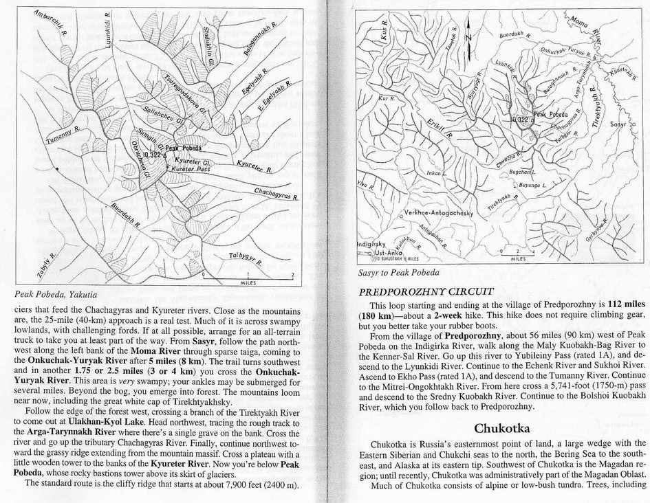
Many treks are shortly described in Trekking
in Russia and Central Asia by Frith Maier, but maps are
insufficient there. Vladimir
Kopylov's site is very good for mountaineering in ex-USSR. Tourism
and mountaineering (and sport in general) were quite supported in
ex-USSR, so there are many Russian language guidebooks
and maps (often drawn by hand, because military maps were
secret), that were issued during past 40 years, but they've been
usually sold already. One can try pages with mountains focus and
Galleries forums (see links )
and try to get some info from locals there. Russian outdoor servers
listed there have often some older guidebooks online, some maps
online....this is the best resource one can find.
|
|
|
|
| |
|
|
|
|
|
|
One can generally get 1:500 000 maps
of Russia in special Russian map shops. Several shops are e.g. near Lublanka
metro station in Moscow . It is sometimes possible to get
better maps of certain areas, but once you are in that area only
usually - and not for sure. So look at my
map page with info where to get Russian military maps
. For Yakutia, Globus map shop in Yakutsk (on main
Lenin street) surprisingly has some 1:300 000 military series sheet,
but not for all areas in Yakutia, unfortunately. For Caucasus,
there is Cartographic Institute in Pjatigorsk, which used to sell maps
as well, but maps on Czech
map server are very good, so no need to look for this. Look at
e.g. bardjur site for
some maps as well as GPS coordinates for some treks (Kamchatka,
Plato Putorana...). And look at my links page, several Russian
outdoor servers have map sections. There is a great site for Polar Ural .
|
|
|
| |
|
|
|
|
|
|
Lonely Planet Russia and Belarus
guidebook is not very useful for trekking or travelling to remote
parts. Well, Russia is so large that quality coverage would have to
consist of several guidebooks probably. And this still waits for some
researcher and publisher.
|
|
|
|
| |
|
Caucasus (1998)
|
|
|
|
|
Most people
visit just Elbrus area, the other
areas are not much visited and not much spoiled by western money. E.g.
well accessible Northern Ossetia (capital
Vladikavkaz) is almost not visited and offers great possibilities for
simple to hard trekking and even an ascent to over 5000m high Kazbek
mountain. Let's skip Chechnya, but Dagestan offers great possibilities
for trekking and meeting many different ethnic groups of people. Czech map server
contains great 1:100 000 military maps for Georgia, Armenia, Azerbaijan
(but some can be used for Russian part of Caucasus as well). So just
look , print and go..... You can use Trekking in
Caucasus guidebook as well (from Cicerone press). I even met one
author of this unique guide (Yuri Kolomiets) on Kamchatka.
Transport
Mountainous Caucasus consists of
generally 5 autonomous regions in the north : Karachevsko-Cherkeskaya
oblast, Kabardinsko-Balkarskaya oblast, Northern Osetia,
(Chechnya+Ingushetia) and Dagestan. International access is usually
best from capitals of these regions. The only international airport
(but used more as a national airport) is Mineralnye Vody. One can fly
quite cheaply there form Europe with Pulkovo
Airlines . Most Czechs go to Caucasus by train. Before an
introduction of a visa regime with Ukraine, they usually went by train
to Kiev (often with a stop on a Slovak-Ukraine border to save on an
international ticket and buy just a very cheap national ticket) and
then form Kiev to Mineralnye Vody or a bit further to a spa town of
Pjatigorsk. One way used to cost around 100 USD. Now, with Ukraine visa
cost of 30 USD, Czech budget travelers go more often through Belarus
(transit visa just 10 USD one way) - there is a direct train during
summer from Minsk (capital of Belarus) to Kislovodsk (through
Min.Vody...) which bypasses Ukraine. Look at train timetable on links page .
I don't need to write anything about Baksan
valley and Elbrus , because Elbrus information site contains
perhaps everything, including maps of Elbrus. Caucasian villages are
generally well connected by buses with regional capitals, so the
transport in not a problem.
How
to lower the risk of being robbed
Robberies are really
an actual problem and the more people go to Caucasus the more
I hear of them being robbed. But people who were robbed usually
didn't follow some rules, which could prevent it. Some
robberies should not discourage anyone from visiting these beautiful
mountains and generally great people.
First, don't sleep
in a tent near villages. If you are in a village (and not staying
in someone's house), go at least several kilometers off. This should
discourage most of local youngsters, who don't have anything to do
(unfortunately there is really almost no work there) and who are
usually the robbers. Sometimes locals claim that Chechens did it,
but they often just blame an easy target.
Second,
try to spend as little nights in a tent built on one place as you can.
Keep moving. This is quite a problem for climbers, who are often off
the tent for several days. Even on very high and not easily accessible
Ushba glacier plato on Russian side of the main ridge, tents are being
visited by robbers (here the robbers are from Svanetia in Georgia
usually).
Third,
be careful to drink spirits with young Caucasians, they have "hot
blood" and seem to be interested in female part of travelers group
especially. Older locals are usually OK all the time, so no need
to refuse their hospitality generally.
Borders
A border permit is necessary
theoretically for any valley leading directly to some pass on the main
ridge (the border with Georgia). But just some of such valleys are
guarded and and permits checked there. So if one does not exactly
know, where they are, better to have it(although they are just on
several places and don't change the place during several years). One
can get these permits for free in border guards headquarters in
capitals of these regions. When border guards are present in the
valley, it is usually a plus - one can e.g. safely build a tent
near them and leave it for some time there.
It should be obvious from
this, that main Caucasus ridge between Russia and Georgia is
no longer passable without potentially serious problems,
although some adventurers might try that and I quite understand them.
There is potentially a lot of adventure waiting there - lawless groups
on southern side in Abkhazia, just a bit better in Svanetia (they rob
on Russian side often), Russian border guards watching some passes by
binoculars from their posts down in the valleys and waiting just
for such adventurers, whole Chechnya with Pankisi gorge in Georgia
occupied by Chechens.... But many parts of Caucasian ridge are
completely off the Russian border guards attention, so it would
be possible to do some carefully planned Russia-Georgia
trekking as in old Soviet times, with a limited risk.
There is an interesting article about the
tragedy of Georgia-Abkhazia conflict at http://www.geocities.com/shavlego/war_wg_1.htm.
Maps to be downloaded from here : Central Caucasus (Elbrus
etc.), West Caucasus
(Archyz, Teberda etc.)
|
|
|
|
|
|
|
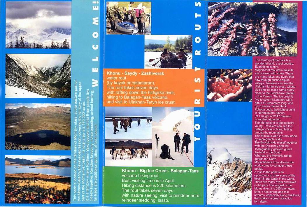
Yakutia -
Chersky mountains (2002)
|
|
|
|
|
If you don't like mountains with other
tourists, then these are the right mountains for you. Even the most
attractive part - Buordakh massif with Pobeda mountain is visited by
just a couple of groups during a year. And the other parts....they are
not visited at all I think.
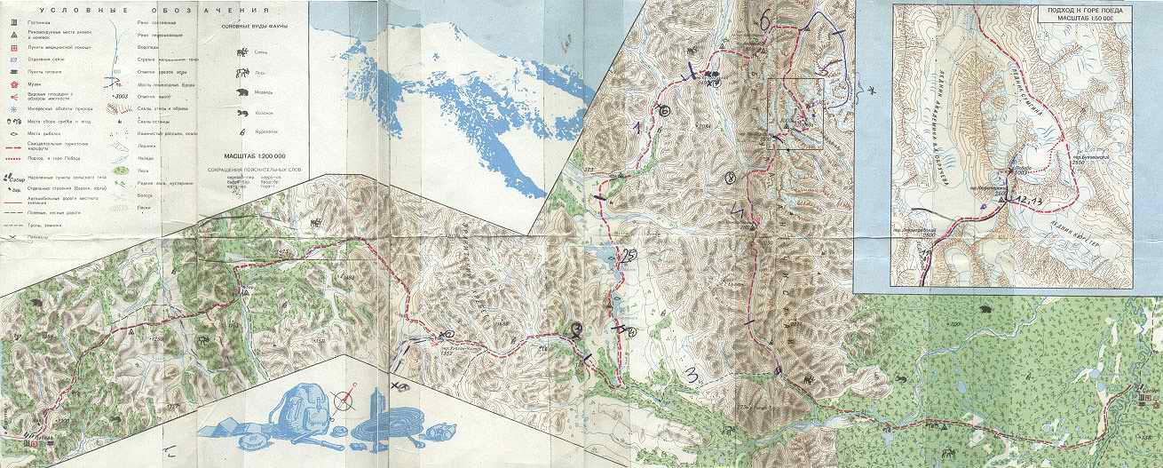
We went to Chersky mountains in summer 2002, you
can look at photos at photo page.
There is a map of our journey there as well. The journey had
several parts. The first part was transport by air to Ust Nera.
The second part was transport by truck to Burustakh valley. The
trird was trek to Pobeda mountain, an ascent of the mountain and trek
to Sasyr. The forth part was by boat and horses from Sasyr to
Khonuu. And the fifth part was by air from Khonnu home.
Transport by air
There were no international or bigger
air companies in Amadeus reservation system, that would to go to
Yakutsk, the capital of Yakutia (or Sakha republic), so we had to
buy a ticket through Russian Sirena system. It was cheaper in
Moscow than through Czech Sirena agent Asiana. Domodedovo Airlines were
OK for flying Moscow-Yakutsk, they even allowed 40kg free of
charge. This would be very interesting for some kinds of
expeditions - e.g. flying to Central Asian seven-thousanders, where it
is almost impossible to have just 20kg.
Ust Nera was connected with Yakutsk by schedule
flights two times a week (we flew this way, about 130 USD for this
flight, when bought in Moscow) , road joining the so called "Kolyma
highway" was not passable during summer.
It was possible to book or buy tickets for the
local Sakha Airlines flight Yakutsk-Ust Nera (or to
Moma/Khonuu) through Sirena system, but the Moma-Yakutsk flight not
in advance (even in Yakutsk). I don't know if it works like
this with some other one-way "back to Yakutsk" air tickets. It is
very good to have these "back to Yakutsk" tickets at least booked,
because airplanes on local flights are small (AN-24). The only solution
is to have someone to book it for you in place where you want
to fly back to Yakutsk from . This can speak in favor of some
cooperation with local travel companies, that have links in these
remote places.
The nearest helicopter near
Chersky mountains has to fly from Zyrjanka on Kolyma river and the
flight from there to the area of Pobeda mountain cost 3500 USD in 2002
(whole helicopter, up to 3 tons of load I guess). We met Russians
who had used it. There is no helicopter in Ust Nera of Khonuu.
Bigger group could rent AN-2 plane from
Sasyr to Khonuu (it can fly in the opposite direction as
well). It would cost about 60 USD one way for each of the 10 people.
This plane goes irregularly this route, when there is enough passengers
and could take up to 12 people. It could be a problem to use small
boats for such a group, considering the Ulakhan Taryn ice crust in half
of the way (see my boat section) and the necessity of more boats for
such a group.
Transport by trucks
Trucks often follow rivers in these
areas, because there is just taiga around and no roads. They sometimes
go straight on the frozen rivers in winter. The best truck for
this transport and the only possible one during summer (when
there is a lot of water in rivers and swamps as well) is URAL. Taking
some other kind, like ZIL, is risky, although someone tells you,
it is OK. ZIL seems to be quite strong truck as well - we were crossing
fords with over 1 meter high water many times, but URAL is better.
Our ZIL from Ust Nera was not able to follow the assumed river and
we had to stop about 2 days of walking before the assumed
destination (Buyunga lake).
Trek to Buordakh massif and Pobeda
mountain and from there to Sasyr
A very important things are a
mosquito net to put over your head and Autan
repellent for other open parts of your body.
The concentration of mosquitos during June and July is
unbelievable, just look a my photos . August is not better, because
mosquitoes are replaced by very small flies (midges), that can even get
through a normal mosquito net. September could be the best, with
average temperatures around 0°C, I guess. Mosquitoes are not
present under 5°C and in even weak wind, but I don't know much
about the small flies. Later, temperatures go down to -50 to -60°C,
so better avoid this time if this is not what one really wants.
The best way to approach
Buordakh massif (where Pobeda mountain lies) is to go by a small car to
Pobeda village (about 100 km from
Ust Nera) and pay for URAL truck, that should stay there, to take you
where you want on the way to Sasyr. We met this URAL going in the
opposite direction while walking. It goes regularly once for a month
from Pobeda village to Sasyr with products and back. The road is
generally just truck trails over taiga, sometimes swampy meadows and
river fords. It would take about 7 days of walking to get from Pobeda
to Sasyr I guess, we walked almost this route in fact (we started near
Pobeda - although we did not know that at that time and finished
the trekking with some detours in Sasyr). I still can't understand, why
our driver did not take exactly the route URAL was taking (from Pobeda
village to Sasyr), maybe he did not know it. You must have a driver
that knows the way, because there in no "way" in fact there.
It's very easy to
follow these URAL truck tracks from either Pobeda village or
Burustakh valley (where we started) over small Ulakhan Chistai
pass and further on to the ford over Tirekhtiakh river. A beautiful
place to spend 1 days is Buyunga lake. You can see it on photos. There
are many smaller lakes around as well. We met local Evens camping there
during whole summer. These lakes are good for fishing.
We left some food near the ford over
Tirekhtiakh river and continued for 2 days through the forest
and over the slopes of Buordakh massif mountains to Kjuerter valley
(this leads to Pobeda mountain). There is no path from the ford, one
has to use a map and stay above the forest, if posible, so it's easiere
to walk.
We went back from Pobeda to the ford by an
approximatly the same way. We were supposed to meet local Momsky
NP people there and to continue alone by their catamaran to
Khonuu. This was arranged by phone with their headquarters in
Khonuu. The place of meeting was set just approximately according
to our map and we somehow did not meet (mainly due to our bad
assumptions). So we decided to walk so Sasyr. On the way to
Sasyr, when we reached the ford again, we could not find where the
tracks continue on the other side of the river (Sasyr side). So we just
walked in the right direction throuth the forest and somehow hit the
right way in about an hour. It was easy to follow these tracks again to
Sasyr.
It takes 2 days from the ford over
Tirekhtiakh river to Sasyr. There is a beautiful lake
with a house, where horsebreeders stay, about 15 km before
Sasyr. This could be the place, where you could
arrange horses when comming from Sasyr.
Pobeda mountain
It is not a hard ascent, but
not pleasant or nice as well. One can approach Pobeda from the west
over Obrucheva glacier, but an approach from the east by
Kjuerter valley to Kjuerter pass is more common. It is about
one day of walking from lower forested parts, over rocks, along the
sometimes wild Kjuerter river, to the glacier leading directly to the
pass. From the glacier one can go up and down in one day without
problems (not more than 10 hours, it took us about 15 hours, but in bad
weather + we started about 2 hours below glacier and returned there).
The easiest way starts from
Kjuerter pass and one goes over the upper part of Obrucheva glacier and
up the snow+ice kuloar to a small pass on the main ridge.
Then there are about 200 unpleasant meters up over the sharp and
not at all fixed main rock ridge in the direction back to the top
(approx. grade III). An ice axe, crampons, rope and some fixing
material are necessary. This is the route we took. A more
difficult routewould be from Kjuerter pass straight on the
main ridge over the smaller top to the main top (approx. grade IV). The
most difficult way would be to go from Obrucheva glacier up
straight to the top (approx. grade V). But if one is not interested in
Pobeda (just because it is the highest mountain about 1500 km around),
there are better looking peaks with more solid rock in Buordakh
massive. Pobeda seems to be just a heap of stones.
Transport by boat and horses
Rivers were the ways that enabled
en exploration of Siberia several centuries ago. But with the lack
of roads and flights being expensive, they are very important for the
transport nowadays as well.
There could be probably several small motor
boats (taking up to 6 people incl. driver) in Sasyr. Khonuu, the
capital of Momsky district is about 300 km far from Sasyr following
Moma river. There is no road along the river (along parts only). The
river is very slow and quite shallow (although quite wide), so we had
to switch the motor off sometimes. And we broke one propeller
anyway. The river is so meandering, that is was sometimes faster
to walk straight than go by boat around.
There are many faster rivers
around, good for rafts or catamarans and Moma is definitely not among
them. I'm lucky we went by motor boat finally, because catamaran was
broken. At the place of Ulakhan Taryn ice crust, the water is so
shallow (and flowing under the ice crust, if it is there, sometimes)
that the boat can not pass. We had to walk about 30 km and another
boat, that came from Khonuu, was waiting for us.
One can use horses for these
30km. Horse breeders stay just at the beginning of this "ice crust"
when coming from Sasyr. In summer 2002, there was almost no ice crust
there, just a lot of streams to ford, so horses were great for that and
incredibly cheap as well (about 2 dollars for a day for one horse, one
usually pays 10-20 USD for a day in tourist mountains like Altai).
Momsky National Park
It was founded
in approx. 1995, partly to protect its area against the mining for
gold in  neighboring Ust
Nera region. Not many tourists visit this area, just a few
international and Russian groups during summer and autumn. Not more
that 10 groups, sometimes very small, so all tourists are worthy guests
here. Momsky NP staff, which works like a cheap
travel company, is a good partner for e.g. booking of a return air
ticket from Khonuu (called Moma on the air timetable) back to Yakutsk,
organizing a small motor boat with a driver on Sasyr - Khonuu route,
organizing hunting and any kind of exploration etc. One
pays approx. real expenditures only in my view and
salaries very low in this area, so it's not
expensive. Momsky district (capital Khonuu) is generally much
cheaper as fas as services is concerned, than the Oymyakonskyk district
(or at least the area of it's capital - Ust Nera). There are
many mines (mainly gold) in Ust Nera area. neighboring Ust
Nera region. Not many tourists visit this area, just a few
international and Russian groups during summer and autumn. Not more
that 10 groups, sometimes very small, so all tourists are worthy guests
here. Momsky NP staff, which works like a cheap
travel company, is a good partner for e.g. booking of a return air
ticket from Khonuu (called Moma on the air timetable) back to Yakutsk,
organizing a small motor boat with a driver on Sasyr - Khonuu route,
organizing hunting and any kind of exploration etc. One
pays approx. real expenditures only in my view and
salaries very low in this area, so it's not
expensive. Momsky district (capital Khonuu) is generally much
cheaper as fas as services is concerned, than the Oymyakonskyk district
(or at least the area of it's capital - Ust Nera). There are
many mines (mainly gold) in Ust Nera area.
And  what is more
important, they are great companions, especially Voloda from
Sasyr. But there is no general phone connection to Sasyr, so one has to
call/fax to the director of National Park to Khonuu. This park is
not big according to the staff (about 10 people, half in Khonuu, half
in Sasyr), but great is both nature and and size. what is more
important, they are great companions, especially Voloda from
Sasyr. But there is no general phone connection to Sasyr, so one has to
call/fax to the director of National Park to Khonuu. This park is
not big according to the staff (about 10 people, half in Khonuu, half
in Sasyr), but great is both nature and and size.
The contact (taken from
their leaflet) should be : Momsky National Park, 12 Lebedev St., Khonu,
Momsky ulus, Republic of Sakha (Yakutia), 678760, Russia, tel.:+7 250
21378. Their time is minus 11 hours from GMT (UK).
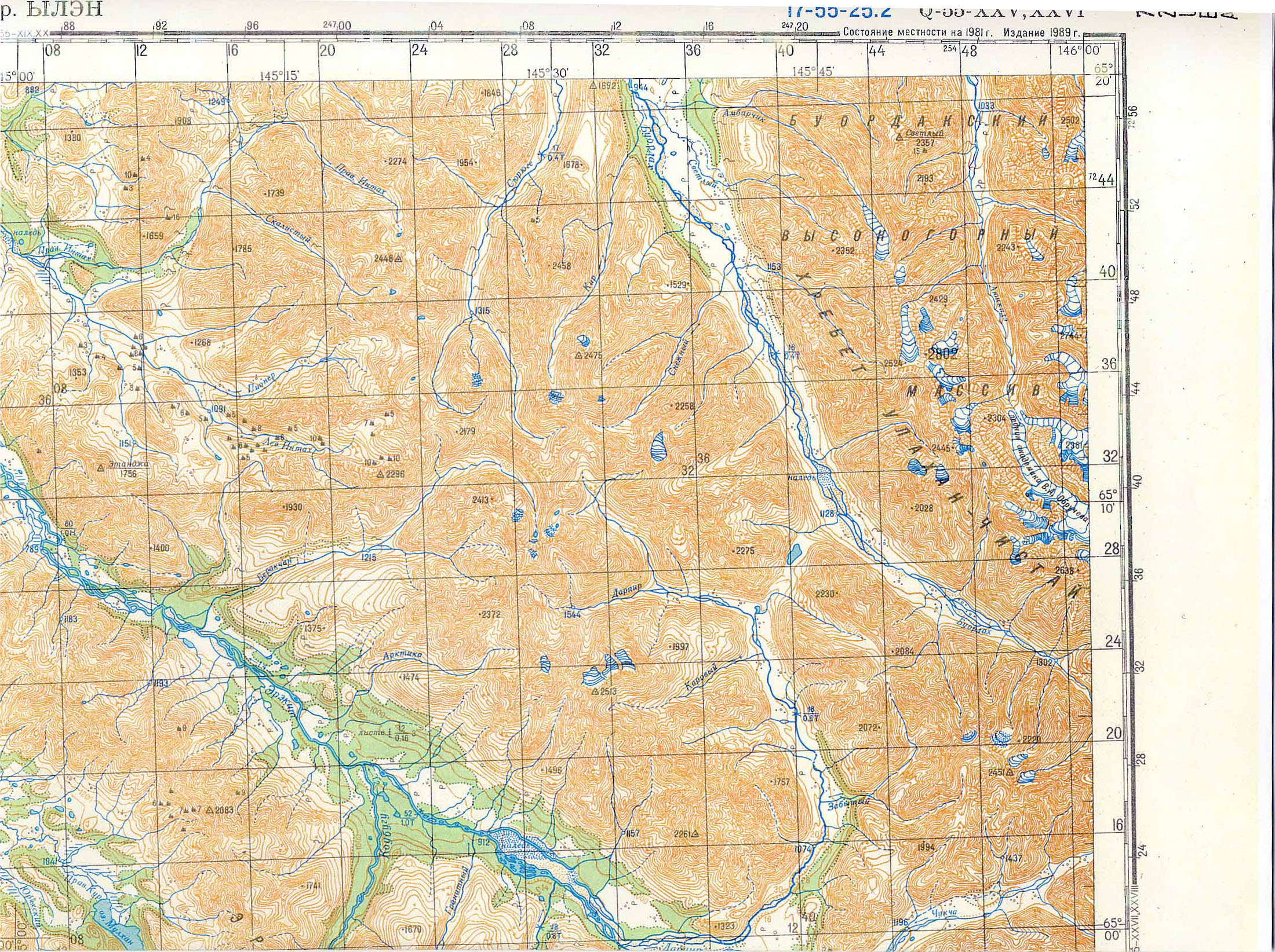
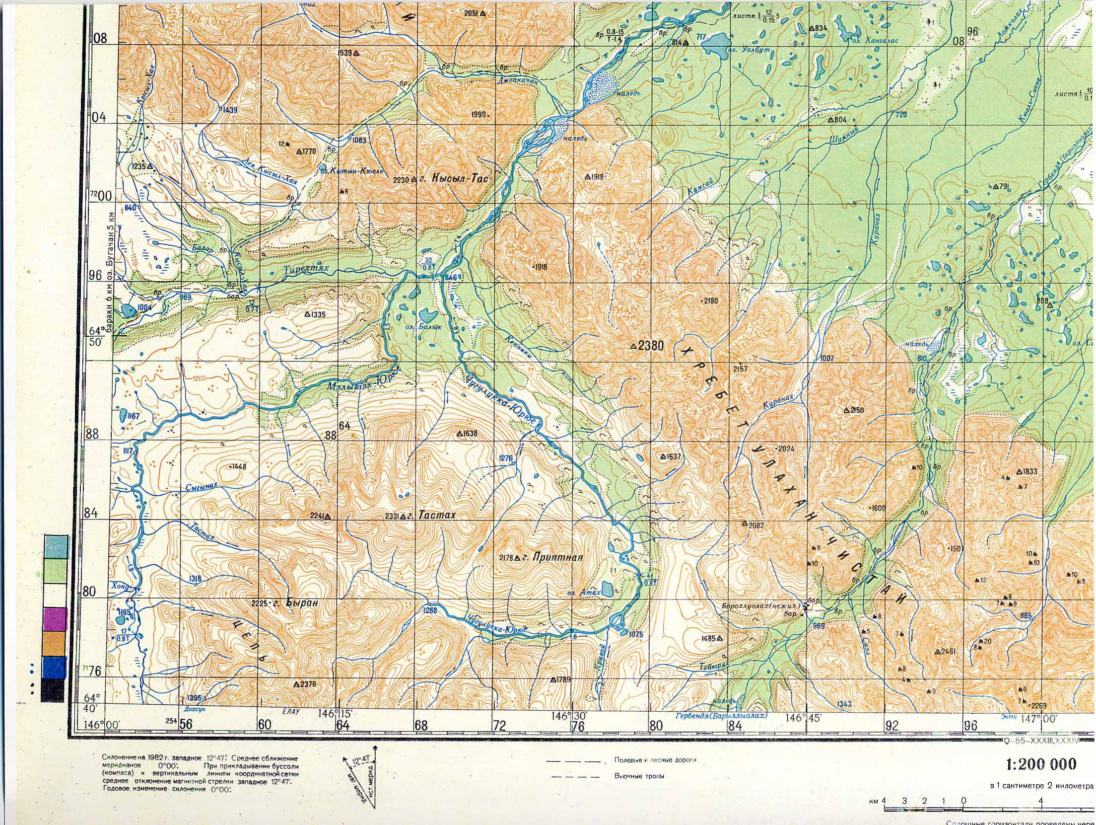
Maps
The first and the most important thing for
independent trekking is a good map. The best is 1:100
000 military series, but I don't know where to get them. They had them
on the wall in Momsky NP headquarters in Khonnu. 1:200
000 military series maps that we had were sufficient. But one had
to get used to their scale.
These tourist maps we got by email from some Polish (who
were there before), when we returned.
Pobeda tourist map - all
Pobeda tourist map - detail 1
Pobeda tourist map - detail 2
Pobeda tourist map - detail 3
Page
from Trekking in Russian and Central Asia about Pobeda
Military
maps 1:200 000 scale of Pobeda region that I used (as I did not
have the tourist maps) to be
downloaded here (A4 size when printed) : 1 2 3 4 5 6
Links
Guidebook for Buordakh massif(in
Russian) !!!we did no have it!!! - originally at St. Petersburgh
tourist club site , but it is quite slow, so I put it here.
Yakutia
travel site - some info and some descriptions of companies' tours,
in English
Yakutian
web with some links - in
Russian only
Russian nature reserves
- site like this describing all of them would be great, in English
|
|
|
|
|
|
Yakutia -
Suntar mountains (not yet visited)
|
|
|
|
|
This
area, a few houndered kilometers from previously visited Chersky
mountains, should be very similar - possible to combine trek with
horses and going back by small inflatable boat that horses could carry
(using e.g. Tyry river to get back). When approching Mus Khaya
mountains from north, there should be horses (possible to rent) in a
valley one west of the main approach valley from the north. I plan to
go there sometime. Maps for anyone interested to go there are here now.
Tourist plan bought in Yakutsk in 2002 -
front page.
Better resolution of this Russian tourist plan here(to be printed on A4
pages approx.)
Classical Russian military topographic 1:300 000 maps to be
added soon.
Detailed "otcot" in Russian incl. maps and
a lot of photos from Suntar mountains trek and river trip by
Delkyu-Okhotskaya river into Pacific here.
|
|
|
|
| |
|
Polar Ural (2003)
|
|
|
|
|
Polar Ural is
a quite popular arctic/tundra trek region among Russians, because
the accessibility by train. The train separates Polar Ural into
two parts. The highest mountain (Paier) is just 1499m high, it is
rocky, surrounded by steep snow slopes (in winter). In my opinion,
these mountains are more interesting for spring ski tours,
than for summer walking. In summer, I would expect quite a lot
of small lakes and swamps there, almost no trees. I would prefer
higher mountains generally for walking.
Where to go
There
are many areas, where one can go.
More people go to the south of the railway than the the north I
think (at least in winter).
If you have 14-16 days, you can make the classic
long tour from Sivaya Maska station (still on Moscow -
Vorkuta line, so even a fast train stops there) along and over the
Polar Ural ridge to the area of Paier (the highest mountain) and end in
Eleckaia station.
If you have less time (e.g. 7 days), you can e.g. start in Eleckaia and
go approx. 2 days over plains to the area of Paier, climb the
mountain, some mountains/passes around and go the approx. the same way
back (we did this journey).
You can start in e.g. Sob station, where mountain
slopes start just from the station to the north as
well as south etc....
Transport
Two trains go every day
from Moscow
during winter. One is normal and it stops after
Seida (the station where the railway divides in the directions to
Vorkuta and Labytnangi) every 5-10 km, so everywhere (even there is
just one hut around, the stops are called like 110 km, 120 km
etc....). Second train is fast one and goes to
Vorkuta, but this does not stop everywhere and does not go in the
direction to Labytnangi of course. The train is pretty cheap, about 25
USD for approx. 48 hours journey. There is no flight to Vorkuta, one
can fly to Salekhard, but it costs almost 200 USD. If the river Ob
is not frozen enough for going over the ice and not defrozen enough for
the ferry, you may be forced to use an expensive short helicopter
flight ! (at least I was told this by one local).
When to go
Most groups go there between
March 20
and April 20 for ski trips. Temperatures are quite mild in this period,
between 0 and -20 C usually. The sooner you go, the lower
temperatures and stonger winds you can theoreticaly expect. The later
you go, the greater the risk of temperatures around 0 and possilbly
snow+rain is. Morevover, one will not be able to
cross many rivers, when they are not frozen enough! Snow is generally
present there till the end of April (for skiing), but because of the
rivers, better to go till the middle of April. It is especially
unpleasant if you go on the way there over some river and can't
cross it on the way back (e.g. river Elec just 500m from Eleckaia, you
can hope someone will see you from the village).
How to see local people
There are very few villages,
that would
be occupied by mostly local (e.g. Nenets) people. I don't know of any
reasonably rechable. Nenets are nomads, they travel with their reindeer
herds (see photos), so you can predict, where to see them. The best
predictable way to see them, their tents some reindeers (not big herds)
is to come on Reindeers day ("den olenovodov" in Russian). This
celebration day takes place in almost every district with larger
population of original people. One has to find out the exact date from
local administration.
Maps to be downloaded from here
- Polar Ural region 1:500 000 up to the
sea in the north (suitable eg. for river trips as well) 1 2 3 4
- Detailed
maps 1:100 000 of main ridge - I used subset of this - here
Good 1:100 000 military
series maps can
be found on Czech
map server.
Many tour descriptions in Russian ("otcety") can be found e.g. on Russian tourism site. There's
a special site dedicated to
Ural region, with lots of maps (1:100 000,1:200 000 ...). I don't
know of any map, that would mark the passes and mountains exactly
(with all their names) . One has to try to decode it from the
Russian tour descriptions ("otcety") according to the location
description of each pass/mountain probably.
|
|
|
|
|
| |
|
Kamchatka (2003)
|
|
|
|
|
Kamchatka offers very
much to tourists and theoretically all of this can be seen even
during a single visit. Snow covered volcanoes, moon like
desert around them, hundreds of hot springs, rivers with tons of
salmons, beautiful autumn colors, geysers as well
as clouds of mosquitos and miggies during summer, hardly
passable bushes and forests almost everywhere and possibly
many enexpectable rainy days.
When to go
If you ask someone on Kamchatka, then
you'll probably hear, that September should
be the best (as in all Siberia I think). Colors of nature are
the best, ranging from green over yellow to red, there are no mosquitos
and probably no miggies as well (although I have doubts about the
miggies unless it is freezing). But September does not suit everyone,
so many masochists (me as well) go there in July or August. It is
common in both Kamchatka and Yakutia, that there are
mosqitos without miggies in July and mosquitos plus miggies in August.
Miggies are worse then mosquitos in my view, but don't bite over fresh
layer of Autan repellent. Anyway, they are so nasty, that you almost
can not eat outside the tent, because they end in you meal. Mosqitos
avoid such suicide missions. It is worth to say as well,
that there are almost no mosquitoes or miggies in Petropavlovsk area
and very little in Mutnovskaya-Gorely
or Tolbachik-Kluchevskaya volcanoes area from my experience.
And there are very much of them around rivers of central Kamchatka. I
don't know about the concentraion in Nalychevo. I hope I will not
go to such areas in July or August again (but I thought that last year
as well, I probably forget quickly).
And winter is always an option
as well. Randonee skiing from volcanoes, sometimes with the ain of
helicopter, is becoming increasingly popular there. International dog
sledge races take place sometime in March I think.
Unfortunatelly, atfer quite extraordinary June a
July 2003 almost completely without rain, we had more than half of
rainy days during our 16 days on Kamchatka in August 2003. It seemed
from a discussion with other Czech groups (we met five just
during our short stay), that when there was bad weather in the north
(Kluchevskaya), there was quite good weather in
Petropavlovsk (Nalychevo).
Where to go
Most of the best photos of volcano activity
and geysers is from Valley of geysers and Uzon
Calderra in Kronotsky NP. I originally planned to go
from Tumroks over Kronotsky NP to Valley of geysers without paying 50
USD / person / day + the same for a compulsory guide. After
reading Yuri Kolomiets opinion about Kronotsky NP, I decided
to end in Tumroks. But I did not see so many great photos of
Kronotsky NP before that. After buying a great book "Miracles of
Kamchatka", I regret it. We had bad weather anyway, so I want to return
to Kronotsky NP some time later, in a few years. Going there without
paying, when you have to leave by helicopter from there (better not to
come by helicopter there) means some possible troubles, of course. But
the park rangers located there don't have much money themselves, so one
would make some deal good for both side for sure. Russians did it this
way in 2002 as well.
Nalychevo nature park is
very popular.It is just about 30 km from Petropavlovsk, just about 2
days of walking along good path. There are many termal springs there,
even a shop with basic products (and beer !). You can bath in the
springs and drink cold beer. There are many volcanoes around
and the river Nalychevo goes directly to Pacific, so many salmons
should be there I guess. A quite good map of the area (with marked
paths) could be bought there in 2003.
Kluchevskaya vocano is popular
because of its height. It would be safer to take a helmet for that
ascent as well, one Czech died there when a stone hit him in 2003. Plosky
Tolbachik volcano is polular because of its moon like
looking area and views to Kluchevskaya. A good trek can
be done in this area.
Travel companies itineraries are a very good
source for an inspiration, e.g. Wild Russia.
I visited Kamchatka for the first time in 2003,
after hundreds of independent Czech tourists were there
during previous 5 years. Several Czech groups put
information about their treks on www. There were some practical
information on www (in Czech or English)about trekking in
Kljucevskaja area, Nalychevo area
and Mutnovskaja-Gorely area and I wanted to add a new
area. I wanted to go somewhere else and to enhance the described space.
After reading an interesting site in Russian (bardjur),
in English (Yuri Kolomiets) and finally the
Russian Tourist guidebook for Kamchatka (part of it I scanned and put
here - see bellow) , I decided from the trek number 11. From
Tolbachik over Tumroks hot spring and Kizimen volcano to the village of
Lazo, about 200 km and it was scheduled for 14 days of trekking
(including 3 rest or reserve days). This trek goes a lot over forests
and bushes, so it is nos so spectacular as e.g. trekking around
Kluchevskaya volcano. But you can see bears, mooses, catch fish.
Where to stay and register visa
The fastest option seems to
be to spend one night in a hotel, that is able to register you.
There are I guess 10 hotels like that in Petropavlovsk. One of the
cheapest, where we staye was Edelweiss, within the walk distance
from bus station in Petropavlovsk (30 USD/person for the cheapest
room). The cheap rooms were full (better to book it in advance), so we
finally managed to persuade the administrator to give us registration
without staying in their rooms for 20 USD/person. They let us to stay
in dormitories, which were in the same building as this hotel (this
building is in fact quite ugly block of flats, typical for
Siberia) for this price. The dormitories even had a common passage with
this hotel. The hotel arouse from this dormitories apparently. But the
dormitories administrator claimed that she could
not accomodate foreigners there without the Edelweiss hotel
intermediation.
Results of my discussion with other Czech
groups : there was no problem to go without special permit to
previously problematic Oktabrskoe or Kluchi, the fastest and cheapest
registration was with police in Esso village (immediately, 1
USD), some hotel in Paratunka is able to register you as well (possibly
for lower price than Edelweiss)
Local transport
The only regural transport by bus seems
to be from Petropavlovsk to Kluchi (about 600 km to the north, so
on the way Atlasovo, Kozyrevsk...) and Oktabrskoe (to the west, on
Okhotsk sea cost). And roads are not asphalt type even there. Buses
there leave from the bus station, which is on the 10th kilometer, that
means on the side of Petropavlovsk close to Yelizovo. A lot of
places is marked by the distance from Petropavlovsk in the direction to
Yelizovo). A lot of buses with numbers around 100 go there from
Yelizovo airport for less than 1 USD. Hotel "Edelweiss",
where we stayed because of the visa registration, about 1 km from there
in the direction to Petropavlovsk centre.
Long distance bus from
Petropavlovsk to Kljuchi leaved Petropavslovsk at 8 A.M. in 2003.
I cost about 20 USD incl. luggage to Kozyrevsk, went 10 hours I
guess to Kljuchi, 9 hour to Kozyrevsk. So you'll be at 17 o'clock
in Kozyrevsk and you still have
time to arrange a rented URAL truck to take you to
Leningradskaya huts from there the same day. There
may be 2 busses going there, but tickects can be sold even a few
days before anyway. These buses are pretty fast with regard
the the road condition, pretty cheap in comparison with
rented cars and pretty comfortable (everyone has a seat). So if
you want to go by this bus and there are not tickets for e.g. next day,
better to go somewhere (like Mutnovsky - Gorely volcanoes for 2-3 days)
and postpone the journey to the north. Another bus just to
Altlasovo (about 8 hours, 15 USD incl. luggage) leaved at 9 AM I
think.
Kamchatka is pretty bussiness oriented towards
tourists nowadays, so prices of rented car with
driver are pretty high. It is better to avoid travel companies at all,
because their prices can be twice bigger. The problem for many seems to
be, that almost no drivers and even not all travel companies staff
speak English. If you speak Russian, then it is better just to ask
some drivers standing at bus stations or generally standing everywhere.
They can know someone owning car who has time to go...
For a smaller group (up to 8 people) rented
4WD microbuses are enough and they are very common all over
the Kamchatka. You can't go with anything less robust generally,
because there is almost no asphalt on (and you don't see much less
robust cars there anyway).Kamchatka It it worth to say as well, that
bigger wehicle, like bus, is faster of these road full of stones,
because of the size of its wheels. We were about 30% slower than the
bus on Petpavlovsk - Kozyrevsk road in ordinary 4WD
microbus, better to avoid it (but there are more robust
versions of these microbuses as sell, like the one we were using for
Petropavlovsk-Mutnovsky volcano journey). When negotiating a fair
price, you can generally count with about 15 USD/hour for the driver
for several hours long distances or about 10 USD/hours for more than
one day journeys. These should be the normal prices, you could
negotiate a bit lower maybe, but a travel company will charge you
several times more as well. Price for fuel could be included it
this price already, but it is quite cheap (less than 1/2 USD per
liter), so it does not form the main part of the transport price
anyway.
This calculation is derived from our price of a
car from Petropavlovsk - Kozyrevsk. It was about 12!!! (bus is
just 9) hours there, plus almost the same back for the driver and we
paid 250 USD for this. We went in a less robust 4WD microbus
unfortunatelly. This is almost twice more the the regular long distance
bus, but the tickets were sold for that morning and we wanted to go
immediately. A very good and friendly driver with quite robust 4WD
microbus (we used if for Mutnovsky volcano) in Petropavlosk told us, he
takes about 15 USD/hour there for shorter journeys. Unfortunatelly for
someone, he does not speak English. The contact for him is : Kostja
Kostarev, tel. 58756 . He can help you to find cheap
flats for rent as well. I recommend him.
A much more robust URAL or GAZ 66 truck
(with bus like cabin for passanger usually) is needed to go almost
anywhere else than the long distance bus goes. I don't have a
contact on an owner of such a car, unfortunatelly. In
Kozyrevsk, there is usually such a car waiting, especially when
you arrive by regular bus. Almost anyone in any village knows who owns
such a car, usually. And that is the place you need to hire
it, you will not need such a car right from Petropavlovsk
anyway. The normal price for a 4 hours long journey in URAL from
Kozyrevsk to Leningradskaya is 200 USD. Kronotsky NP office in
Lazo village owns GAZ 66 and they are able to go from Lazo to
Leningraskaya as well. The price would be similar but the route goes
along the fields of 1975 Tolbachik eruption, about 15 km from
Leningradskaya (normal a long one day trip). They also one a very
old (about 40 years) bus, that can be used for an approach to Tumroks
hot springs. Contact for a very friendly (and not so
business oriented as many others) Kronotsky NP employee "Vova" : Vladimir
Tavrilov, ul. Komsomolskaya 7, Lazo, tel.: 8233/26415. He can
arrange the bus to Tumroks, GAZ 66 truck etc.
Horses are generally not very widespread on
Kamchatka, so don't count on them. Horses can be arranged in e.g. in
Lazo, to go to Tumroks (they would manage it in one day, I think,
because it was 1 1/2 days of walking).
Petropavlovsk - THE TOWN of
Kamchatka
There are about 450 000 people on
Kamchatka and 350 000 of them live in and around Petropavlovsk. That's
why it's called just "the town" among locals. Some places are
identified according to their distance from somewhere in the town
center. The bus station is on 10th
kilometer, the market and "Russian book" bookstore (selling
the great "Miracles of Kamchatka" book) on 6th
kilometer. There is not much to see in the town
itself according to me, so there is no need to spend
more than one day there.
Many people people visit a kind of "etnography"
museum (correct name is "Kamchatsky Oblastnoy
Kraevedchsky Muzei", on Lenin street no. 20). It is
quite small, all texts are in Russion only (at least I was told that),
so small value for the 5 USD entrance fee (for
foreigners). But it was possible to buy Kamchatka tourist
guidebook there.
Many people try to visit "3
brothers" rocks in the sea at the mouth of Avacha
bay. Arranging a small boat for 1/2 day would be very expensive in
Petropavlovsk prices probably (>100 USD), so we tried to get
there by a rented car along the coast. We passed a military building
and finished at the end of a passable road, in front of a
cliff. That was about 5 km to the south from Zavoiko
peninsula. Public bus goes just to Zavoiko (because there is an area of
block of flats there) and the dusty road along the
coast starts when you pass the resident area and
leave it on the right side behind you. There were seagulls and
other birds at the sea coast and one could see some rock in the
sea (on my photos). But it was not one of the "3 brothers rocks"
probably. Anyway, I liked this short car trip and recommend
it.
I can not recommend visiting any travel
agencies in Petropavlovsk (and probably anywhere in
Kamchatka). Prices of transport are high anyway there and travel
companies charge even much more. But I can recommend buying steamed
salted fish on the market or visiting a good bistro (self service
cafeteria) on Lenin street, about 100 m after Lenin square (the square
where a statue of Lenin still stands !).
I don't know much places to stay in the town, we
stayed one night in Edelweiss hotel because of the visa registration
and then one night in a rented flat (arranged by Kostja Kostarev, tel.
58756, for about 20 USD for the flat).
Tolbachik to Tumroks trek
This should be the trek for
lovers of taiga forests and lava fields as well. You'll
see black lava fields at the beginning of this trek also.
The trek begins near the place of the famous Tolbachik
volcano eruption, at former volcanological station called
Leningradkaya (because it was used by volcanologists from
Leningrad, now St. Petersburg, probably). It would be
possible to make this trek longer, by starting with the ascent of
Kluchevskaya volcano and continuing over Tolud pass from there.
Russians did it approximately this way, although they went to
Kluchevskaya from Leningraskay. It had an advantage of
leaving some products at Tolud hut I think. We did not have so much
time. You can read description of their trek plus get more GPS
coordinates at http://bardjur.narod.ru/. They were my
inspiration for this trek as well.
You should see Kluchevskaya group of volcanoes
very well from Plosky Tolbachik if the weather is good. You may expect
to see bears or elks down in the valley as well. But
with several days of rain, this trek was not a pleasant one for
us. We had no expected view of Kluchevsky volcano from Plosky
Tolbachik, no ascent of Kizimen volcano and no view of Kronotsky
volcano from there. And no wiews on mountains around
during the expected 3 days of wilderness with no path (result was
almost 5 days of such wilderness).
An ascent of Plosky Tolbachik
volcano can be done in one day without problems. It
takes about 6 hours up and 4 hours down to Leningradskaya huts.
Most of the distance is just a mild slope, over the dark lava
sand and rocks later. The right way for the final ascent to
the crater edge goes by the small ridge on the right side, unless you
want it to be much steeper. You should find the right way with the
coordinates. The whole path itself is not very clear, especially in the
mist.
55°44.344,160°16.806 Leningradskaya
baza huts, 1194m
55°45.662,160°18.426 From Len. baza to
Plosky Tolbachik
55°46.845,160°19.926 From Len. baza to
Plosky Tolbachik
55°47.464,160°20.313 From Len. baza to
Plosky Tolbachik
55°47.669,160°20.248 From Len. baza to
Plosky Tolbachik
55°48.333,160°20.975 From Len. baza to
Plosky Tolbachik
55°48.678,160°21.562 From Len. baza to
Plosky Tolbachik
55°48.438,160°21.692 From Len. baza to
Plosky Tolbachik - the ascent ridge
55°48.875,160°22.060 From Len. baza
to Plosky Tolbachik - the ascent ridge
55°49.008,160°22.279 Plosky
Tolbachik crater edge, 2865m
55°48.967,160°23.010 Top of Plosky
Tolbachik, 3038m
The way to Talud hut is
quite easy, because one can go everywhere, the terrain is passable
easily. The exact path is not very clear, but it is not important
anyway. Later, we continued along the dry riverbed of some river that
run paralel with Talud, following bear's tracks by the way. We hit the
river finally and continued along it for some time. Talud
river disappeared in sand later and we continued
just the sand plains to hit Right Tolbachik river
. This was the end of good path for several later days. This took 2
days.
55°44.177,160°17.997 From Len. baza
to Talud river
55°44.183,160°17.996 From Len. baza to
Talud river
55°44.432,160°20.130 From Len. baza to
Talud river
55°45.214,160°22.301 From Len. baza to
Talud river
55°45.105,160°23.905 From Len. baza to
Talud river
55°44.749,160°24.739 From Len. baza to
Talud river
55°44.065,160°25.668 From Len. baza to
Talud river
(55°45.025,160°25.468 Talud hut, we
turned south about 1km before we would reach it )
55°42.473,160°27.757 Talud river -
when we hit is for the first time
55°38.590,160°31.284 Along Talud river to
south
55°35.572,160°31.863 Right Tolbachik
river - when we hit is for the first time
Better to follow Right Tolbachik river for
several kilometers along it's current and go through the
dense forest between Right and Left Tolbachik
in a place, where the rivers are close (about 2 km from each
other). We crossed Right Tolbachik too soon and it took us 3 hours to
overcome 4km distance between the rivers. The guidebook even goes
the the meating of these rivers. This takes 1/2 day.
55°34.685,160°30.022 Still
close to Right Tolbachik on the way to Left Tolbachik - bad way
55°33.061,160°30.755 Left Tolbachik
river - close to Berezovy brook meeting
55°32.508,160°30.739 We hit Berezovy
brook for the first time
There is a not very visible path
up along the Berezovy brook to Berezovy pass (1
day). The pass consists of beautiful meadows. The following part of the
trek is the worst (2 days). If you go along the Left
Shapina river, you will end in swamps sometime. But there are
some meadows there, so it is not just bush and thick forest. If you
want to avoid swamps, you have to go over the slopes of the hill on the
left side of Left Shapina river. But you'll go up and down through a
pretty thick forest. Nothing is ideal. When you reach the bridge
over Left Shapina, then you are on the good Tumroks-Lazo path
and you are saved. This takes about 3 days.
The times when Tumroks hot springs resort
was just a few huts are past now. New hotel style wooden builidngs with
luxury rooms were built there in summer 2003 for rich tourists comming
by helicopter. Most of the building are now owned by "WelcomeTour"
travel agency. I didn't like the light color of these buildings,
located in still total wilderness with no road around. We stayed
there 2 nights in a bit underground small hut for
free. Left Shapina is full of salmons, if you have a large net and an
ability to work with it.
55°30.563,160°31.272 Small
hunter's hut (for 2 people) on Berezovaya brook
55°29.473,160°32.170 Nice meadow
below Berezovy pass - the last water on this side
55°29.058,160°31.572 Berezovy pass -
altitude 736 m
55°27.591,160°31.482
Izvilistny brook - the first on this side of the pass
55°26.061,160°31.210 Kruglye lakes
55°15.575,160°22.656 Bridge
over Levaya Shapina river (path from Tumroks to Lazo)
55°13.719,160°24.238 Path
to Tumroks, it is a bit complicated in this area
55°13.553,160°24.089 Path to Tumroks, it
is a bit complicated in this area
55°13.521,160°23.973 Path to Tumroks, it
is a bit complicated in this area
55°12.218,160°23.995 Tumroks hot
springs resort
Tumroks-"Koral" route
(the place where a road to Lazo starts) takes 1 1/2 days. One can
sleep in huts at the lake. The path is good and it is possible to
go on horses as well if you arrange them in Lazo. It take's about 2
hours to get from a place called "Koral" to Lazo by the more then
40 years old bus of Kronotsky NP or any other 4WD car. The nature
is beautiful along this path - mountains meadows with lots
of blueberries and several lakes.
55°16.200,160°19.804 First
nice meadows on the way to Lazo (no water there)
55°18.484,160°19.235 Huts at the
lake, good for sleeping
55°24.515,160°14.165 Hut at the beginning
of a jeep road to Lazo
Mutnovsky volcano
I didn't want to
visit Mutnovsky-Gorely volcanos originally, because many people
had gone there already. But we changed our original plan because
of the bad weather in central Kamtchatka. I was lucky to go there
finally. Mutnovsky volcano with its phenomenons of volcanic
activity combined with its accessibility was very rewarding.
We could see steams, sulphur natural objects, blue
crater lake, stones of many different colors etc. We
didn't manage to visit Gorely volcano (which lies just at the
opposite side from basecamp), because of the bad weather.
There should bec several small crater lakes there,
but not much of other phenomenons of volcanic
activity as fas as I know.
If one is short of time and wants to visit just
Mutnovsky volcano, it is possible to do it with rented
truck even during one long day (from Petropavlovsk). The
usual basecamp, which lies approximately
between Mutnovsky and Gorely volcanoes, is about 4 hours' drive from
Petropavslovsk. Better to have some more robust car then the usual 4WD
minibus, because this can have problems to pass over snow fields. If
you have URAL od GAZ66 truck, you can be dropped about 1 hour after BC,
right at a start of an ascent canyon . The
easiest way is to follow URAL tracks from BC to the start of the ascent
canyon. The path in the canyon it good and clear then. No gude is
needed at all. When you reach the area of suphur and steams, don't
forget to continue over that, althouth the area may
seem like the end of the path. The path is leading to a
beautiful crater lake and even further to the edge of a second
crater. There's a rope for the last few meters below this edge. This is
really end, I think. The ascent takes about 3 hours from BC, about
2 hours from the end of the passable road.
There's a beautiful canyon with a
waterfall just a few hundered meters down from the the place
where truck tracks end under Mutnovsky volcano. See coordinates and
don't miss this small detour.
If you want to save money, you
can go from Petropavlovsk by a public shared minibus (from bus
station probably) to Paratunka hot springs resort. Then walk to
the start of the road to Mutnovskaya (see coordinates, there's a
private thermal pool there as well) and hitchhike further. There are
many trucks going to Mutnovskaya hydrothermal power
plant. But these trucks can take you to the place where road
the BC separates only (see coordinates). It's about 6 km from there to
BC. Rented travel agencies' trucks with tourists seemed to be pretty
full, so I wouldn't rely on a ride directly to BC too much.
52°51.029,158°09.358 Start of the
road to Mutnovskaya hydrothermal power plant
52°35.014,158°07.650 Road to Munt.
basecamp separates from the road to the power plant
52°30.179,158°07.403 Usual
basecamp area (with most tents) - altitude 970 m
52°28.863,158°08.525
End of truck tracks under the canyon to the volcano
52°28.270,158°09.449 Cross at a small
hill above the canyon to the volcano
52°27.815,158°10.080 Area of
steams on Mutnovskaya
52°27.547,158°09.752 Blue
lake at the crater - altitude 1595 m
52°28.609,158°07.789 Waterfall in the
canyon under the volcano - altitude 1362 m
52°35.567,158°12.246 Before Mutnovskaya hydrotermal
power plant
Some other usefull GPS coordinates
55°36.182,159°38.439
Atlasovo village, bus stop
53°04.104,158°36.151 Edelweiss hotel
in Petropavlovsk
55°46.259,160°14.920 Vodopadnaya,
water is here when there in no at Leningradskaya
55°36.371,159°44.372 ferry over
Kamchatka river between Atlasovo and Kozyrevsk
55°55.281,159°40.724 ferry over
Kamchatka river between Lazo and Atlasovo
Maps, links
The famous scanned Atlas of
southern Kamchatka can be found on Czech map server or
smaller version (18MB) here
(index map here).
Reasonable look at Kamchatka from an experienced
Russian mountaineer and guide Yuri Kolomiets http://www.risk.ru/eng/people/guide/kamchatka/index.html.
Czech group who was trekking around Kluchevskaya
http://www.kamcatka2002.wz.cz/english.htm
Kamchatka tourist guide 2003
booklet could be bought in the museum or "Ruskaya kniga" (Russian book)
bookshop or at other places like souvenir shops. Apart from basic
information about Kamchatka history, original people (quite useful, the
only info I found in English), flora, fauna, national parks etc. in
both Russian and English !!!, it contains many possibly useful company
advertisements. It contained a street map of central Petropavlovsk as
well. I scanned some pages from it here.
Much better Kamchatka tourist
guidebook in Russian language could be bougt
for 2 USD in the museum (see above Petropavlovsk article). If
you read Russian, it contains much information, even when diffent kinds
of salmons go and their descriptions. I scanned a parth of
this book (the most valuable part - trek descriptions) here :
1 2 3
4 5 6
7 8 9
10 11 12
13 14 15
16 17 18
19 20
Miracles of Kamchatka
by Andrey Nechayev is the best photo book about Kamchatka I've seen so
far. Most of the photos there are from from Kronotsky park, where the
author spent several years probably. It contains valuable texts in
both Russian and English !!! as well. It could be bought for less than
20 USD at "Ruskaya kniga" (Russian book) bookshop. This is the best
thing to buy as a souvenir from Kamchatka.
|
|
|
|
|
|


