 |
|
|
 |
|
 |
| |
|
Transport
Entry formalities
Mountains and
trekking Maps
Other
North of Addis
Abeba South of Addis
Abeba South practical
info
 Ethiopia can offer to a traveller very
much, from historic sites of the north to the tribes of the south. And
all this during almost whole year. The rain season is approximately
summer in the north and spring in the south (Omo valley). But I don't
want to rewrite a guidebook here so just a few practical comments
follow. Ethiopia can offer to a traveller very
much, from historic sites of the north to the tribes of the south. And
all this during almost whole year. The rain season is approximately
summer in the north and spring in the south (Omo valley). But I don't
want to rewrite a guidebook here so just a few practical comments
follow.
Ethiopians know English quite well
because children study it from the beginning of an elementary school.
Later courses and textbooks, even during second part of an elementary
school, are all in English! Amharic (the official language of
Ethiopia) is studied just as a single course during later studies (I
was told this). But to know some Amharic phrases is always a great plus
when communicating with people. David Appleyard's "Colloquial
Amharic" with cassettes is great for more devoted people, Lonely
Planet "Amharic phrasebook" is OK most of the people.
Many travelers, guidebooks and articles on the
web write about a kind of xenophobia in Ethiopia , with
children shouting "faranji" (means foreigner in Amharic) on you. It is
true for the the more visited north, the Highlands (approx. the area of
Amhara nation), especially. But one can get used to it I think and
ignore it quite well. I'm not sure if the reason is a real xenophobia.
It may just be a kind of a game for small children. The south,
with many different non-amharic tribes, is almost free of this.
|
| |
|
| |
|
|
|
| |
|
Airplanes
Ethiopia has remarkably good
national Ethiopian Airlines
. For international flights, they are not the cheapest usually. But
they can be used for interesting African combinations with free of
charge and not time limited stopovers in Addis Abeba. They serve many
other African countries from Addis Abeba. For national flights,
although the foreigners rate is about twice the Ethiopian rate, one can
think if it is better to save 2 days in a bus with 100 USD flight or
not. Flight can be cheaper and more effective then renting of a private
jeep, which costs about 150 USD / day.
One great thing with Eth. Air. is, that if
you do not use your ticket (and you don't have to tell them
before), they will give you all your money back - but in the
office where you bought the ticket only. Dates can be changed for free
as many times as you want as well. So it is a good idea to buy even the
tickets for which you are not sure about the date or even destination
in advance (so you have your seat) in Addis Abeba, where you probably
return eventually (in case of returning an unused ticket). This
flexibility is great. They even accept credit cards in Addis, but then
the refund is in about 3 month to you credit card, not in cash (I tried
that). One bad thing with this flexibility is, than you
should check a day before the flight if the flight is not cancelled.
They can do it if the number of passengers is too low.
The local flights schedule is not on www
unfortunately, but one can request it from some Eth. Airlines office
(national or international) by fax for example. It is a good idea to
buy or book a local ticket before you fly to Addis Abeba in some Eth.
Air. office outside Ethiopia (or by phone to Addis), because some
destinations can be sold out for several days (e.g. Lalibela)
Buses
Buses are a great place to meat ordinary local
people and one should not avoid them completely. They are quite cheap
but quite slow as well. They can travel about 300km for a day only even
on an asphalt road and they don't go over the night at all !. The bus
transport in Ethiopia is quite strictly organized and Bradt guide
even call it a bus ceremony .
The long distance buses depart in the early
morning only usually. They tell you e.g. 5.30 a.m. but this is the time
when a mass of people is allowed to enter the before then closed bus
station compound. Then the luggage starts to be loaded and additional
tickets sold if possible. The real departure is at least 1 hour later,
e.g. at 7 a.m. It is better to have tickets bought from a previous day
(but not necessary), because you can come a bit later, around 6 a.m.
lets say. Conductors usually don't sell more ticket than the number of
seats in the bus fortunately. Buses are quite crowded with people
transporting many things, anyway . Bigger luggage must go compulsorily
on the roof usually and if the luggage man puts it for you there, he
usually requires some payment (I put it there by myself, but had to
argue with them sometimes). Another strange thing - one has to keep the
bus ticket during the whole (even more days long) journey, because
tickets are collected at the end of every journey. Maybe for some
accounting or just bureaucratic purposes, I don't know.
|
|
|
|
| |
|
| |
|
|
|
|
|
|
Simien mountains
Simien mountains are a great place
for short treks, but it is no off the beaten track destination any
more. But it is worth of visiting. I mean the national park area. I
guess you would meet no foreigners outside the park . There is a jeep
road over all Simien mountains unfortunately and it is being
constructed to lead further along Ras Dashen mountain to join the
Lalibela-Sekota road (which leads in the north-south direction). When
this road is constructed, it could be used for mountains bikes for
example ... According to rules, one has to start from park headquarters
in Debark, where it is obligatory to pay a park fee + a fee for a
compulsory scout.
It would be possible to avoid the scout, but one
would have to start from somewhere else than Debark. And better not to
end in Debark as well, because locals are used to see every foreigner
accompanied by an armed scout. One should better miss the usual
villages and campsites in Simiens probably, so it has some
disadvantages as well. But the lack of the scout company could be a
great freedom for some people.
With the compulsory scout, it is not probable to
make any other trek then the usual one (described in both LP and Bradt
guidebooks), because one is allowed to camp at designated campsites
only (but short 1 day detours are possible, with return to the the
official campsite). Better to take a quite warm sleeping bag
(especially if one does not take a tent), because temperatures can be a
bit below zero during the night.
It would be an interesting trek to go
over Simien mountains and continue towards Mekele or Lalibela (for up
to 2 weeks, at least the 1:250 000 maps from Addis would be necessary
for this and better to end in Simiens to avoid starting with the scout
from there). Some people have done this trek, look e.g. here http://www.ag.wakwak.com/~ikeken/africa/index-e.html.
One has to cross the Tekeze river - there should be an interesting book
about rafting this river called The
Lost river.
Bale mountains
Very nice quite flat mountains, especially when
not so dry as on my photos (thousands of Lobelias would be there in
Aug, Nov, maybe even Dec). There are almost no tourists there and it
one has this good map,
it is possible to get off the bus e.g. in a pass with radio tower and
don't go to park HQ (and not to pay any fees, although this was not the
prime reason, the pass is just better located for trek start, I think).
But Harrenna escarpent and forest on the southern slopes of Bale NP are
the most remote and best are here, definitely. With pleasant people, as
well.
|
| |
|
| |
|
Northern Ethiopia - for people
with no special interest in Eth. Orthodox Church |
|
| |
|
Most people go to northern Ethiopia to see
old sites of Ethiopian Orthodox Church . Guidebooks list several
must-to-see places like Gondar castle, village of Lalibela, Lake Tana
monasteries, Blue Nil falls, Simien mountains etc. I was mostly
disappointed with all these highlighted places (except for Simien
mountains - see above and partly Lalibela). But it could be because of
my too high expectations before and experience of hospitality in remote
mountains of ex-USSR.
These highlights are generelly full of tourists
and both normal people and local authorities just think how to get
money from them. But if one gets off the beaten track, which can mean
just a few kilometers away or even just to a hotel unlisted in
gudebooks, it can be a great change.
As far as pure spectacularity of these highlights
is concerned, that is more a matter of private opinion. For a person,
who in interested in remote mountains and living unspoiled culture,
these places offter static or dead culture - e.g. a castle,
church....monks just waiting compulsory payment for opening a door of a
church to see some old paintings on the wall. Well, it the country is
not rich enough to pay for conservation of these sites, why the
tourists who arrive should not pay it ? Well, that is true... I don't
visit churches and castles in Europe, so I should not expect anything
more from Ethiopian churches maybe. And there is not much more to see
there than these paintings - I'm writing about Tana lake
monasteries here. Gondar castle is quite a ruin, one can
not go inside (at least in 2001) and I would not pay the high entrance
fee once more. Forget about the "African Camelot" comparison used in LP
guidebook. Lalibela has pretty high entrance fee as well
(approx. 20 USD), but it it is spectacular and unique, even for people
with little interest in Ethiopian Orthodox Church. And the surroundings
of Lalibela consists of not much visited places, mountains,
villages...which do not see so many tourists.
The best way to explore the highlands of
northern Ethiopia in limited time (e.g. 3 weeks) could be to start
in Lalibela (and see some culture there as well...) and continue
trekking to Simien mountains. Not many foreigners have done this
trek...see above mountains section.
|
| |
|
| |
|
| |
|
Southern Ethiopia - practical
experience - Dec 2001, Jan 2006 |
|
| |
|
West bank of Omo - Surma tribe area
- Dec 2001
Bad news in 2003 !!!
Eth. Air. cancelled regular flights to Tum. Surma
tribe became much more unaccessible. One can try a jeep road from the
north there (about 200 km, almost no cars I guess) or nice about 6 days
long trek along the jeep road from Jinka (shorter if you hitch some
Park Office car). Or drive from Omorate to Kibish on Sudanese border
and walk for several days to Surmas.
This tribe is one of the least visited in
Southern Omo, because it can't be easily reached by a car
(fortunately, in comparison with very similar looking and much more
visited Mursi). LP guide at least mentions this tribe, Bradt guide does
not mention it at all. But they can be easily reached by flying to
Tum (regular Ethiopian Air. flight in small 18-people airplane,
from Addis Abeba, with several other stops, twice a week in 2001). I
can't remember the cost , I think about 100 USD one way.
Tum is just a grass airfield with a few
houses. No car is there, but porters or guides could be hired there if
needed. From Tum, one is in half a day in Maji, the biggest village on
the way. Without guides or previous knowledge, it is better to follow
the jeep road. It is longer than the path that locals use, but one
can't get lost (I was following this jeep road as well). Maji
is the main village in the area. There was no car there when I was
there, just one motorcycle. But I managed to get some kerosene there
for my gas stove (probably better to get it in Tum, where the airport
is). No other road leads to Maji than a poor jeep road from the north,
I think. (plus the one from Tum). From Maji, it is possible to go
through the village of Mui (jeep road, about half day of
faster walking) to the first Surma village - Kibish (one day
of faster walking from Maji, in is not the Kibish marked on the maps
north of Omorate, ot the border with Sudan...).
Outside Kibish , there is just a
territory of wild Surmas...the most interesting territory of course...I
plan to return there to explore this area more than I did when I was
there alone just for 2 days. I haven't seen any foreigners there, this
is pretty remote area :-)
Going first to Kibish (as I went) is not a good
solution . First, I was required to pay 50 Birr (about 8 USD) for
staying in Kibish (for services of policemen or for what ...). And
second, the boss of Ethiopian militia in Kibish did not want me to
leave Kibish to explore other Surma villages alone. He gave me 1
Ethiopian militia man + 1 local Surma militia man for another 50 Birr a
day. The payment would not be the main problem, but these "guides" were
quite lazy and did not want to go all the way I wanted. Next time, I
would tell the militia in Mui that I go to Kibish, if they asked at all
and I would avoid Kibish to explore many small Surma settlements around
freely.
East bank of Omo (Hamer, Dasanech, Bana
people) - Jan 2006
Jinka
By location and surrounding green hills, this is
a plesant town. But not by peope. Local teenagers start to terribly
anonying if you want to go by truck (and probably rented car as well)
somewhere out. They will say, they there are 'official' brokers to
supply truck drivers with passangers and start to be really aggressive
when you want to deal with drivers themselves. Prices on often VERY and
DANGEROUSLY overcrowded truck are serveral times higer for foreigners
(I think even 10x). And to our surprise, neither these 'brokers' nor
drivers were willing to negoitate a more realistic price - they rather
take no foreigner (faranji), than to take them for reasonble price
(that would be still higher than local, but not 5-10 times).
We flew from Addis Abeba to Jinka to save time - good thing, but them
wanted to travel by local transport as it's normally cheaper and better
for contact with local people. But here, it was a mistake not to hire
4wd private car for maybe only 2-3 days. Instead, we were waiting e.g.
2 days in Omorate for a terrible truck full of empty bottles, that
charged us prices higher tham rented 4wd car (for 4 people) as the
driver knew, we had no other choice. And again, if you don't want to
pay such price (e.g. 200 birr per person Omorate to Arba Minch), you
don't go, no business atitude - I would call this even hostile atitude.
So if you fly to Jinka already to save time, rent a 4wd there,
otherwise both cost and time saving will be lost while waiting for
overpriced trucks.
Key Afer, Turmi, Omorate
Once out of Jinka, Bana and Tsemai people aroudn Key Afer are quite
pleasant.They even don't insist on payments for photos. Hamer, although
quite pleasant as well, do insist on payment for photos. Omorate -
quite anoying people. Truck sits on the west bank of Omo and that goes
sometimes with goods to Kibish on Kenya border and Bume village on west
bank (opposite to Murle on the east). We were supposed to go there, but
the driver changed mind and went elsewhere. Omo river is nice to see
here, as is Dasanech village on the other bank - but it's a terrible
photo business, with people too eager to be photographed for money.
Generally, I was not impressed with people here.
Arba Minch and around
We set for an overnight trip to explore the bare
hills around Mt. Guge (about 3600 m I think). It easy to follow a good
dirty road to a village Mesho (coordinates : 6.261560, 37.526790), Mt.
Guge can be then seen about 2 hours away. This was a nice short thip,
spoilt a bit by the fact, that we were from morning till evening
followed by a teenager who wanted some money (later more childern came,
so it ended with throwing stones etc.). Hopefully, other foreigners
will be able to avoid this.
Nechisar park - worth of approx. half day trip by rented 4WD, price
about 800 birr. If people plan to rent 4wd anyway, better to have it
already, as such price is generally quoted for full day rent for
several days. My friend walked all the way to the hot springs (and went
back by car), we found this too long and exhausing - but good for
people with a lot of time. Gazeles, crocs, zebras, pigs, hippos,
monkeys and birds can be seen (from car as well).
|
|
|
|
|
| |
|
|
|
| |
|
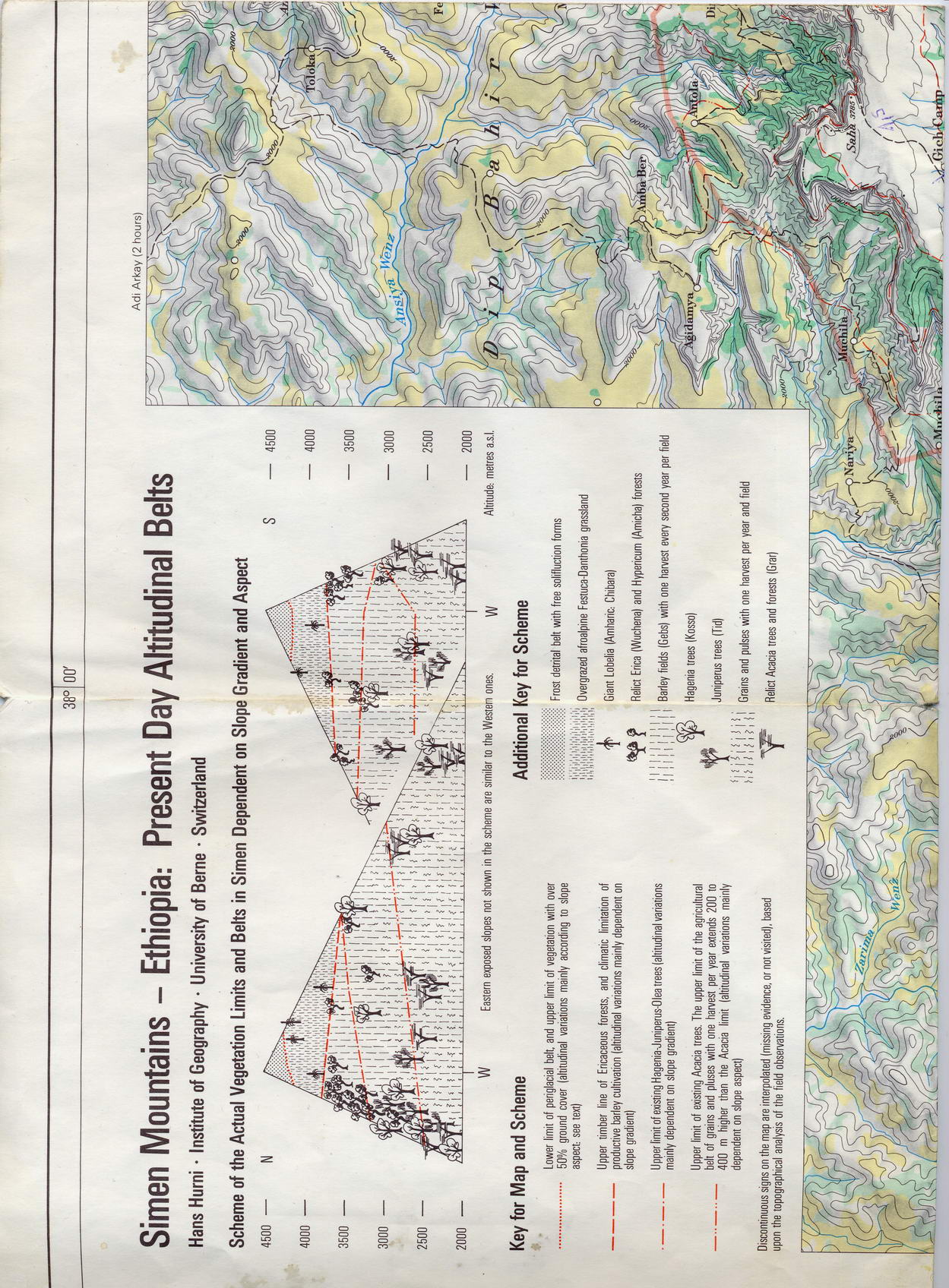
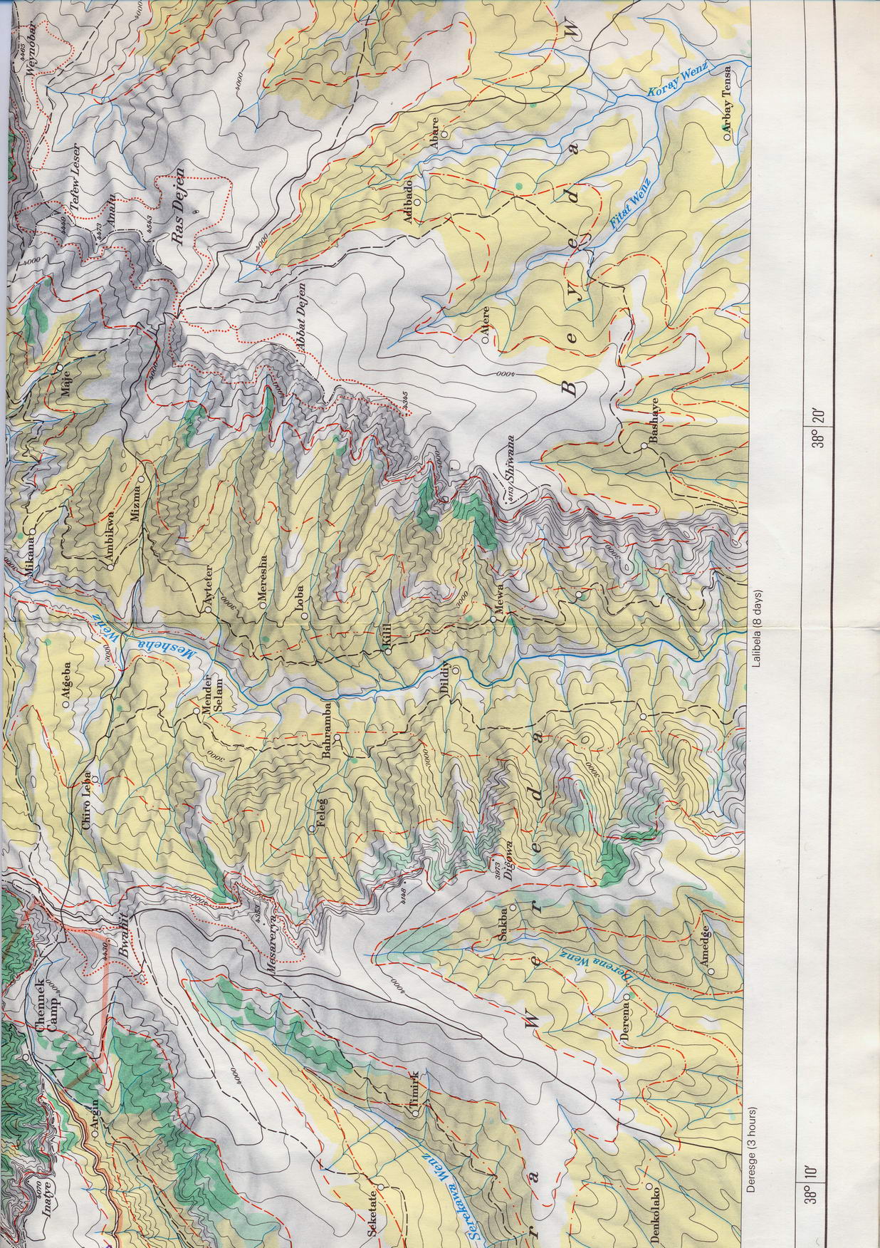
The only map usable for trekking available outside Ethiopia is a Swiss
published 1:100 000 Simien mountains map (very good) and one
for Bale mountains.
Simien
mountains map - left lower
Simien
mountains map - left upper
Simien
mountains map - middle lower
Simien
mountains map - middle upper
Simien
mountains map - right
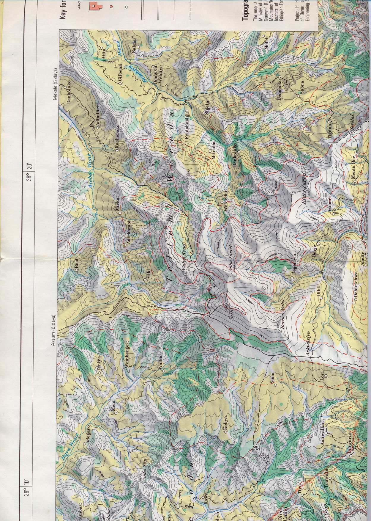
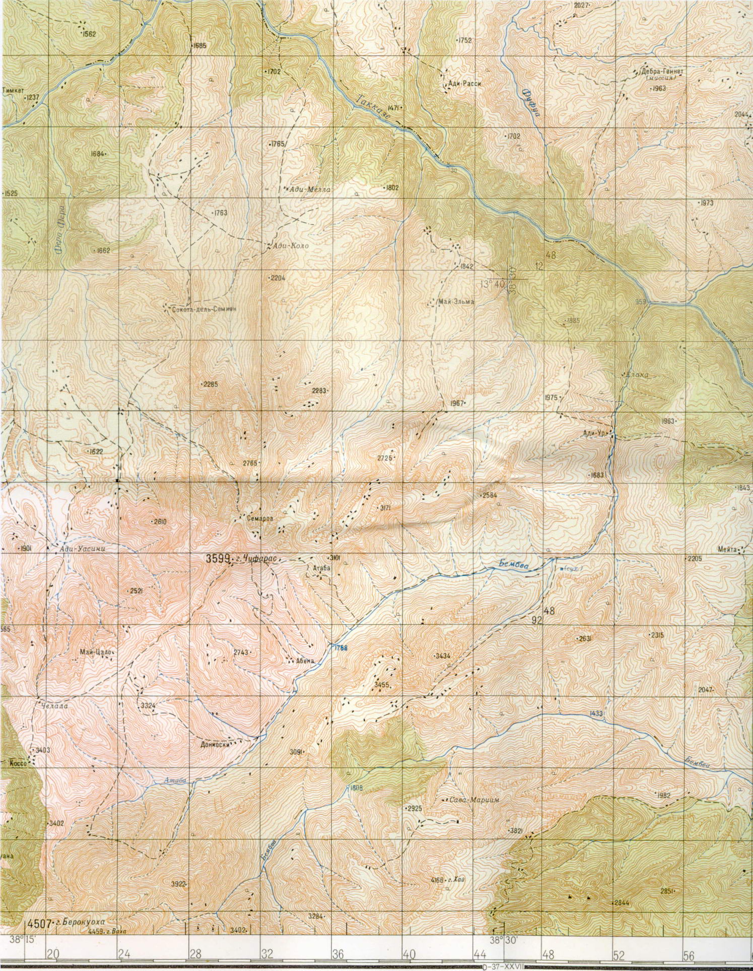
The only solution for all other areas seems to be 1:250 000 maps from
Ethiopian Mapping Authority (EMA) or 1:200 000 Russian
Military maps series (see some down here). These Simien
maps are usefull e.g. for approach of Simien mountais from the east -
from Lalibela/Sekota or better Mekele. The trip that I was thinking to
do in 2000, then 2004 but never did. Let them be usefull to someone
else that does it despite the limited usefullness of Russian
military maps in Ethiopia in general.
Simien
Tekezze north - left
Simien
Tekezze north - right
Simien
Tekezze south - left
Simien
Tekezze south - right
Danakil
Assale - left
Danakil
Assale - right
One needs a written letter from Ethiopian
Tourist Commission (located on Mesqel square, quite near to EMA
fortunately, see LP or Bradt guide) to buy 1:250 000 EMA maps
of requested areas. One can generally get maps of all Ethiopia with the
exception of border regions. This exception can be a problem sometimes
- e.g. many sheets covering Omo valley area cover parts of Sudan, so
cannot be purchased.
1:200 000 Russian military series maps are old as well,
roads are drawn approximately only, names of villages are often not
very usable now. But they are topographically quite good and they can
be acquired for all Ethiopia including border areas. See University of
California page for Omo region or commercial map shops for other
areas. Maps of Omo region take are available online - see sheets
coverage with marked sheets available for download in 1 zip archive here.

Bradt guide writes about 1:50 000
maps in EMA
but questions the availability to buy them even with the permission. I
doubt such maps can be bought, at least they were not shown to me when
I asked what were the best maps possible to buy. It is possible to buy
1:1 000 000 sheet of all Ethiopia in EMA without permission if I
remember.
EMA is open on weekdays only, till
about 5 p.m. if I remember. The address for EMA is : P.O.Box 597, Addis
Ababa, tel:01 518445, fax: 01 515189 according to Bradt guide. It it
marked in the guidebook map, physical location is near to Hilton hotel.
It is just up the to top from the Tourist Commission, on the left side.
|
|
|
|
| |
|
|

